Scotland’s Railways · Port Road explorer
The Port Road: Dumfries to Stranraer
A railway across Galloway, linking rural communities with Dumfries and the Irish Sea crossing at Stranraer.
Keep exploring the Port Road
Choose another section
The complete set of Port Road subjects remains available throughout the route.
Photographs & film
The Port Road visual archive
Explore photographs and films of the railway, its trains, communities, surviving places and structures.
The visual record
The railway and its landscape
Every displayed item retains its location, date or period, creator, licence and source.

11 August 1960 · photograph
The Carlisle–Stranraer Harbour express at Dumfries
Black 5 No. 45455 at Dumfries with the 2.25 pm Carlisle to Stranraer Harbour express, a photographed Port Road working five years before closure of the direct route.
Ben Brooksbank / Geograph, via Wikimedia Commons
CC BY-SA 2.0
Creator-licensed photograph; attribution and ShareAlike terms apply.
Source and rights →
7 May 2019 · photograph
The former Castle Douglas station site
A modern view east towards Buittle and Dumfries. It records the cleared station site and surviving railway landscape rather than the station as it appeared in service.
Nigel Thompson / Geograph, via Wikimedia Commons
CC BY-SA 2.0
Creator-licensed photograph; attribution and ShareAlike terms apply.
Source and rights →
2 September 1991 · photograph
Dalbeattie station site looking towards Dumfries
A dated post-closure view looking east across the former station site towards Dumfries. It records the railway alignment after removal and is not presented as an operating-era station photograph.
Ben Brooksbank / Geograph, via Wikimedia Commons
CC BY-SA 2.0
Creator-licensed photograph; attribution and ShareAlike terms apply.
Source and rights →
7 May 2019 · photograph
The former Dalbeattie station site
A precisely located modern record of the station site. It is not presented as evidence of the station's 1965 appearance.
Nigel Thompson / Geograph, via Wikimedia Commons
CC BY-SA 2.0
Creator-licensed photograph; attribution and ShareAlike terms apply.
Source and rights →
7 May 2019 · photograph
Crossmichael station site
A modern view north-west along the former platforms towards Parton. The source records that the former signal box visible in 1986 had subsequently been removed.
Nigel Thompson / Geograph, via Wikimedia Commons
CC BY-SA 2.0
Creator-licensed photograph; attribution and ShareAlike terms apply.
Source and rights →
7 April 2003 · photograph
Loch Ken Viaduct
A modern record of the surviving viaduct north of Parton. It establishes the structure's survival, not its operational condition in the final passenger period.
Simon Brooke / Geograph, via Wikimedia Commons
CC BY-SA 2.0
Creator-licensed photograph; attribution and ShareAlike terms apply.
Source and rights →
July 2002 · photograph
Stroan Loch and Viaduct
The surviving viaduct and loch in the railway landscape west of New Galloway station at Mossdale, photographed after the trackbed became a path.
Colin Smith / Geograph, via Wikimedia Commons
CC BY-SA 2.0
Creator-licensed photograph; attribution and ShareAlike terms apply.
Source and rights →
23 April 2013 · photograph
Big Water of Fleet Viaduct
A modern view of the major surviving structure east of Gatehouse of Fleet station. The photograph documents the structure after railway closure.
Billy McCrorie / Geograph, via Wikimedia Commons
CC BY-SA 2.0
Creator-licensed photograph; attribution and ShareAlike terms apply.
Source and rights →
14 January 2007 · photograph
Gatehouse of Fleet station remains
The remote former station site, several miles from the town it served, with surviving platforms and railway buildings in the forest landscape.
Richard Webb / Geograph, via Wikimedia Commons
CC BY-SA 2.0
Creator-licensed photograph; attribution and ShareAlike terms apply.
Source and rights →
7 May 2019 · photograph
Creetown station building and forecourt
A modern record of the restored station building and forecourt. It is clearly separated from any claim about the station's operating appearance.
Nigel Thompson / Geograph, via Wikimedia Commons
CC BY-SA 2.0
Creator-licensed photograph; attribution and ShareAlike terms apply.
Source and rights →
8 May 2019 · photograph
Palnure station site
A modern record of the exact station site, whose passenger service had ended before the Port Road's final timetable period.
Nigel Thompson / Geograph, via Wikimedia Commons
CC BY-SA 2.0
Creator-licensed photograph; attribution and ShareAlike terms apply.
Source and rights →
8 May 2019 · photograph
Newton Stewart station and junction site
A modern view east from the bridge towards Palnure and Castle Douglas. Behind the camera the former Whithorn branch diverged from the main route.
Nigel Thompson / Geograph, via Wikimedia Commons
CC BY-SA 2.0
Creator-licensed photograph; attribution and ShareAlike terms apply.
Source and rights →
8 May 2019 · photograph
Glenluce station site
A modern view south-west towards Dunragit and Stranraer, recording the surviving building and former railway setting.
Nigel Thompson / Geograph, via Wikimedia Commons
CC BY-SA 2.0
Creator-licensed photograph; attribution and ShareAlike terms apply.
Source and rights →15 May 2015 · video
Dunragit signalling and the surviving railway
A modern signalling record at Dunragit, with additional Glenwhilly context on the surviving Girvan route. It is not evidence of 1965 signalling arrangements.
Filmed by Nick Jones and Matthew Morgan; Friends of the National Railway Museum
Copyright; source page permits reuse except sale or advertising
Remote Vimeo player linked through the Scottish Railway Signalling source page; no video file is copied and playback never autostarts.
Source and rights →
9 May 2019 · photograph
Castle Kennedy station site
A modern view east towards Dunragit and Castle Douglas at a point on the section that remains connected to Ayr and Glasgow.
Nigel Thompson / Geograph, via Wikimedia Commons
CC BY-SA 2.0
Creator-licensed photograph; attribution and ShareAlike terms apply.
Source and rights →
8 May 2019 · photograph
Stranraer Town station site
A modern view at the former forecourt. This is kept distinct from Stranraer Harbour station and does not reconstruct the site in passenger use.
Nigel Thompson / Geograph, via Wikimedia Commons
CC BY-SA 2.0
Creator-licensed photograph; attribution and ShareAlike terms apply.
Source and rights →
12 July 1983 · photograph
The morning Euston train at Stranraer Harbour
A dated railway scene at the harbour terminus eighteen years after the direct Port Road closed. It documents the continuing rail and maritime endpoint, not a train over the closed route.
Aubrey Dale / Geograph, via Wikimedia Commons
CC BY-SA 2.0
Creator-licensed photograph; attribution and ShareAlike terms apply.
Source and rights →1965, shortly before 14 June closure · archive film link
The Port Line
Dan Maclachlan's 26 minute 50 second colour and sound film records the rail journey between Dumfries and Stranraer Harbour shortly before closure. The detailed NLS shot list identifies route stations, line-side activity, scenery and the harbour endpoint.
Filmed by Dan Maclachlan; National Library of Scotland Moving Image Archive
In copyright — personal private viewing only
Catalogue link only. The film and stream are not copied or embedded; contact NLS to obtain a copy or public-use licence.
Source and rights →
7 May 2019 · photograph
Parton station — modern comparison
Surviving station building, now a private residence, photographed from the former forecourt. This is a post-closure comparison, not a view of the operating railway.
Nigel Thompson / Geograph
CC BY-SA 2.0
Creator-licensed photograph. Credit and source retained; CC BY-SA 2.0 applies. Display may crop responsively; enlarged view shows the complete image.
Source and rights →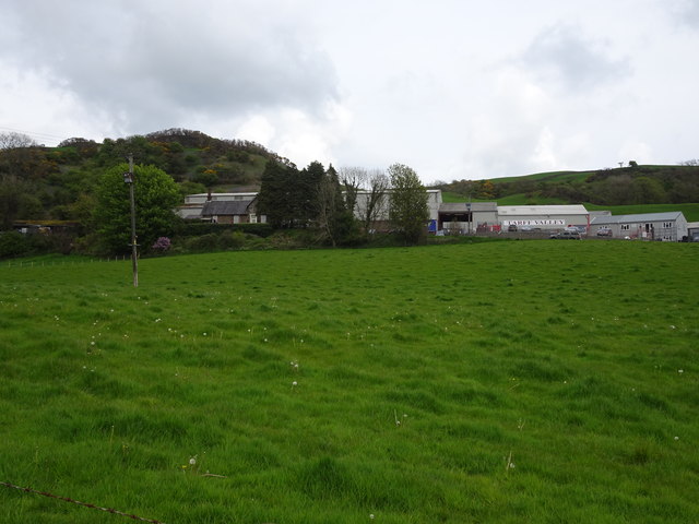
7 May 2019 · photograph
Tarff station — modern comparison
The old station building is visible within the former station site, used as business premises in this photograph. This is a post-closure comparison, not a view of the operating railway.
Nigel Thompson / Geograph
CC BY-SA 2.0
Creator-licensed photograph. Credit and source retained; CC BY-SA 2.0 applies. Display may crop responsively; enlarged view shows the complete image.
Source and rights →
8 May 2019 · photograph
Kirkcowan station — modern comparison
Platform ends survive beside the altered station site; the road crosses part of the former station. This is a post-closure comparison, not a view of the operating railway.
Nigel Thompson / Geograph
CC BY-SA 2.0
Creator-licensed photograph. Credit and source retained; CC BY-SA 2.0 applies. Display may crop responsively; enlarged view shows the complete image.
Source and rights →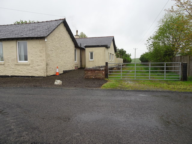
7 May 2019 · photograph
Killywhan station — modern comparison
A modern view of the former station site looking towards Kirkgunzeon and Castle Douglas. This is a post-closure comparison, not a view of the operating railway.
Nigel Thompson / Geograph
CC BY-SA 2.0
Creator-licensed photograph. Credit and source retained; CC BY-SA 2.0 applies. Display may crop responsively; enlarged view shows the complete image.
Source and rights →
19 September 2019 · photograph
Loch Skerrow station — modern comparison
Station remains with the partly demolished up platform in the foreground. This is a post-closure comparison, not a view of the operating railway.
Adrian Taylor / Geograph
CC BY-SA 2.0
Creator-licensed photograph. Credit and source retained; CC BY-SA 2.0 applies. Display may crop responsively; enlarged view shows the complete image.
Source and rights →
8 July 2018 · photograph
Maxwelltown station — modern comparison
Platforms remain at the former station; the station building had been removed before this photograph. It is not presented as a view of the station during railway operation.
Zentron1 / Wikimedia Commons
CC BY-SA 4.0
Creator-licensed photograph; attribution and ShareAlike terms under CC BY-SA 4.0 apply.
Source and rights →
23 June 2000 · photograph
Lochanhead station — modern comparison
A post-closure view of the station site and surviving railway remains. It is not presented as a view of the station during railway operation.
Ben Brooksbank / Geograph, via Wikimedia Commons
CC BY-SA 2.0
Creator-licensed photograph; attribution and ShareAlike terms under CC BY-SA 2.0 apply.
Source and rights →
21 June 2000 · photograph
Kirkgunzeon station — modern comparison
A post-closure view of the station site, with a later house occupying part of it. It is not presented as a view of the station during railway operation.
Ben Brooksbank / Geograph, via Wikimedia Commons
CC BY-SA 2.0
Creator-licensed photograph; attribution and ShareAlike terms under CC BY-SA 2.0 apply.
Source and rights →
7 May 2019 · photograph
Southwick station — modern comparison
The former station and trackbed survive as a private residence in this post-closure view. It is not presented as a view of the station during railway operation.
Nigel Thompson / Geograph
CC BY-SA 2.0
Creator-licensed photograph; attribution and ShareAlike terms under CC BY-SA 2.0 apply.
Source and rights →
9 February 2008 · photograph
Buittle station — modern comparison
The track on the right leads towards the former station site; only rubble from the railway cottages remained. It is not presented as a view of the station during railway operation.
Chris Newman / Geograph, via Wikimedia Commons
CC BY-SA 2.0
Creator-licensed photograph; attribution and ShareAlike terms under CC BY-SA 2.0 apply.
Source and rights →
15 February 2008 · photograph
New Galloway station — modern comparison
The surviving former station building at Mossdale, photographed from beneath the road bridge. It is not presented as a view of the station during railway operation.
Chris Newman / Geograph, via Wikimedia Commons
CC BY-SA 2.0
Creator-licensed photograph; attribution and ShareAlike terms under CC BY-SA 2.0 apply.
Source and rights →_geograph-3425341-by-Ben-Brooksbank.jpg)
9 July 1996 · photograph
Dunragit station — modern comparison
A post-closure view across the level crossing showing the station remains and continuing railway. It is not presented as a view of the station during railway operation.
Ben Brooksbank / Geograph, via Wikimedia Commons
CC BY-SA 2.0
Creator-licensed photograph; attribution and ShareAlike terms under CC BY-SA 2.0 apply.
Source and rights →.jpg)
17 May 2017 · photograph
Kirkcudbright station — modern comparison
The surviving terminus building, photographed after conversion to a new use. It is not presented as a view of the station during railway operation.
Tom Parnell / Wikimedia Commons
CC BY-SA 2.0
Creator-licensed photograph; attribution and ShareAlike terms under CC BY-SA 2.0 apply.
Source and rights →
8 May 2019 · photograph
The former Portpatrick station site
The former terminus and surviving platform area, photographed after closure. This modern view identifies the station site; it does not show the station as it appeared in 1926.
Nigel Thompson / Geograph, via Wikimedia Commons
CC BY-SA 2.0
Creator-licensed photograph; attribution and ShareAlike terms apply.
Source and rights →
8 May 2019 · photograph
The former Colfin station site
A modern view of the former station building and surviving platform area. It locates the 1926 timetable call but is not an operating-era photograph.
Nigel Thompson / Geograph, via Wikimedia Commons
CC BY-SA 2.0
Creator-licensed photograph; attribution and ShareAlike terms apply.
Source and rights →
8 May 2019 · photograph
The former Wigtown station site
A modern record of the former Wigtown station site on the Whithorn branch. It is shown as a comparison with the railway landscape after closure.
Nigel Thompson / Geograph, via Wikimedia Commons
CC BY-SA 2.0
Creator-licensed photograph; attribution and ShareAlike terms apply.
Source and rights →
8 May 2019 · photograph
The former Kirkinner station site
A modern record of the former Kirkinner station site. It identifies the place called in the 1926 timetable without claiming to show its 1926 appearance.
Nigel Thompson / Geograph, via Wikimedia Commons
CC BY-SA 2.0
Creator-licensed photograph; attribution and ShareAlike terms apply.
Source and rights →
8 May 2019 · photograph
The former Whauphill station site
A modern view of the former station site on the Whithorn branch, presented as post-closure comparison evidence.
Nigel Thompson / Geograph, via Wikimedia Commons
CC BY-SA 2.0
Creator-licensed photograph; attribution and ShareAlike terms apply.
Source and rights →
8 May 2019 · photograph
The former Sorbie station site
A modern view of the former station site on the Whithorn branch. It records the surviving location rather than the station in operation.
Nigel Thompson / Geograph, via Wikimedia Commons
CC BY-SA 2.0
Creator-licensed photograph; attribution and ShareAlike terms apply.
Source and rights →
8 May 2019 · photograph
The former Millisle station site
A modern record of Millisle station, the timetable railhead labelled for Garlieston. The train is not represented as continuing to Garlieston.
Nigel Thompson / Geograph, via Wikimedia Commons
CC BY-SA 2.0
Creator-licensed photograph; attribution and ShareAlike terms apply.
Source and rights →
8 May 2019 · photograph
The former Whithorn station site
A modern view of the former Whithorn branch terminus, presented as post-closure comparison evidence.
Nigel Thompson / Geograph, via Wikimedia Commons
CC BY-SA 2.0
Creator-licensed photograph; attribution and ShareAlike terms apply.
Source and rights →